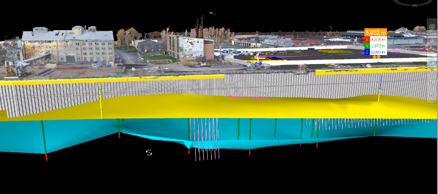

Urban planning has historically focused on the attributes of the city “above ground” when making strategic planning decisions. However, when the attributes below the ground are later on revealed, there are often negative impacts in terms of costs and delays, sometimes even bringing into question the viability of a project as a whole. The main objective of this milestone project is the development of decision support systems (DSS) to help making informed planning and design decisions. With increased urbanisation, the city beneath the surface will become an important resource. The underground offers space e.g. for transportation, materials that can be used for construction, repair and maintenance, and offers other natural resources, such as water and geothermal energy. Thus, an underground Digital Twin of the city will be as important as the Digital Twin above the ground surface. The project will contribute to answering crititical questions such as: How to account for regional subsidence in flood simulations as well as historical land use? How to develop potentially challenging/hazardous areas? How to account how different adjacent structures affect each other in the short and long term? How does the development of new structures and infrastructure and their foundations affect the existing city?